The chances of a wet winter — perhaps one of the wettest in decades, with soaking storms, coastal flooding and other problems — are growing in the Bay Area and across California as El Niño conditions in the Pacific Ocean continue to strengthen.
Read more Sunday’s Viva CalleSJ to explore some new streets in San Jose
On Thursday, scientists at NOAA, the National Oceanic and Atmospheric Administration, said there is a greater than 90% chance of a strong El Niño being present in October, November and December, and a 75% probability that it will rank as the strongest in history since modern records began in 1950, up from 69% last month.
“Interests in California need to be aware that there is an increasing possibility of above-average rainfall and stormier weather,” said said Michelle L’Heureux, a meteorologist with the National Weather Service’s Climate Prediction Center in College Park, Md.
In addition, supercomputer models from many of the world’s top meteorological organizations are showing increasing chances that all of California, not just Southern California — which normally has higher odds of a wet winter than Northern California during El Niño years — could see heavy rainfall, particularly after December.
There’s now a 70% chance that rainfall totals from January to March across the California coast, the Bay Area and much of the state will rank among the wettest 20% of the historical average, according to data from the European Centre for Medium-Range Weather Forecasts (ECMWF), an weather organization based in England that is funded by more than 20 nations.
“The odds of a wet winter are very high,” said Daniel Swain, a climate scientist with the University of California’s California Institute for Water Resources. “I would eat my hat at this point if a significant portion of California doesn’t end up significantly wetter than average this winter.”
There are a number of reasons for the steady shift.
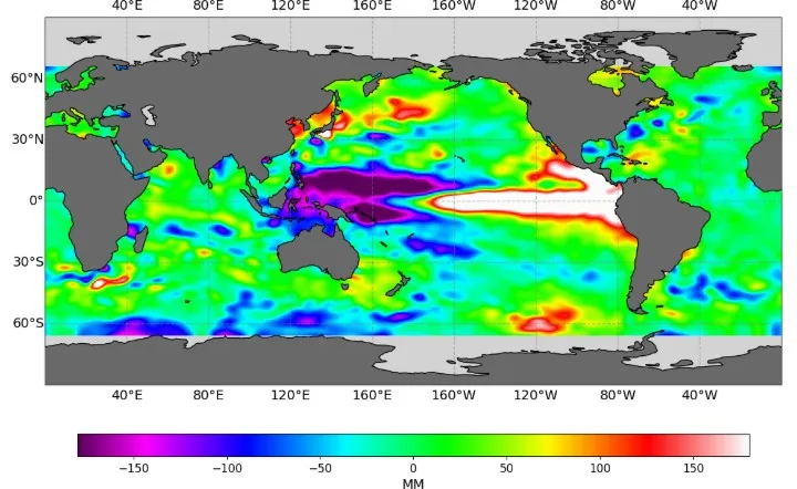
El Niño events occur every 2 to 7 years when ocean waters along the equator off Peru become warmer than normal, affecting weather patterns across the globe. They begin when trade winds that normally blow from the east to the west weaken or reverse, preventing cold, deep-ocean water from rising to the surface. The warmer surface waters become, the stronger the El Niño is considered. The opposite — a cooling of the ocean waters off South America — is called “La Niña.”
El Niño events last for months and can often change the movement of the jet stream, pumping heat and moisture into the atmosphere and creating conditions that allow more winter storms to come to California, particularly Southern California, but also sometimes soaking the Bay Area and Sierra Nevada.
Currently, the Pacific Ocean along the equator is warmer than it has ever been in recorded history, roughly 3 degrees Celsius, or 5.4 degrees Fahrenheit, warmer than average.
That has contributed to humid, very hot weather in Southern California in recent days with tropical-like conditions. It also has helped generate hurricane activity between California and Hawaii. Earlier this week, huge waves from Hurricane Marie, a storm which was hundreds of miles off the coast, hammered Southern California.
More than 30 ocean-front homes in Long Beach, Dana Point, Laguna Beach and other cities were badly damaged Tuesday and Wednesday, including actor Nicholas Cage’s house in Malibu, where a massive sinkhole opened. Waves flooding parking lots and parts of Highway 1, and damaged the historic wooden boardwalk in Long Beach.
“We are now already beginning to see some of the initial effects,” Swain said. “What we’re seeing now is just the beginning.”
Read more San Jose: Man fatally shot Wednesday night
Because of climate change, the Pacific Ocean has risen about 8 inches since 1900, according to tidal gauges at Fort Point near the Golden Gate Bridge. But it will rise more in the coming months due to El Niño.
The warmer waters now — which are up to 15 degrees Fahrenheit warmer than average below the surface now at the equator — expand. They are combining with a phenomenon called “Kelvin Waves,” where winds push ocean water against the coast of South America and it slowly sloshes north for thousands of miles. That will causing another 6 to 12 inches of sea level rise in California in the coming months, scientists estimate.
This winter, if there is a high tide and a heavy storm at the same time when the background ocean is already close to 2 feet higher than its historical average, that could cause significant coastal flooding, damage to roads, piers and cliffs — like Santa Cruz, Pacifica and other cities have already seen in recent winters — and even potential flooding around roads, homes and airports in San Francisco Bay, Swain said.
Jan Null, a meteorologist with Golden Gate Weather Services in Half Moon Bay, said Thursday he agrees that the chances of a wet winter in the Bay Area are increasing.
He said conditions now are looking similar to 1997-98. That year, San Francisco received 47 inches of rain, double its historical average of 23 inches. It was the second wettest year in recorded history since the Gold Rush in California, behind only 1861-62, when flooding was so widespread that newly elected Gov. Leland Stanford had to ride a rowboat through the streets of Sacramento to attend his inauguration.
Null noted, however, that there was not major, widespread flooding in 1997-98. The reason? Despite all the rain, it was spread out over many days, giving rivers and creeks a chance to recede.
“The odds are certainly above normal for an above-normal rainfall year,” said Null, the former lead meteorologist for the National Weather Service in the Bay Area. “But how much above normal? And how is that is that distributed? We don’t know.”
Already, emergency officials in many areas are preparing.
Crews have been working weekends and evenings at the Santa Clara Valley Water District, the main flood control agency in Santa Clara County, on 37 projects to remove debris and sediment from streams and rivers, stabilizing banks, and taking other steps to reduce flood risk, said Matt Keller, a district spokesman.
The last major flood in the Bay Area came in 2017, when Coyote Creek overtopped its banks, causing $100 million in damage to neighborhoods around downtown San Jose. The water district has upgraded flood protection on several sections of that creek, and is already running drills at its emergency operations center to prepare in case similar conditions arise this winter, Keller said.
State officials at the California Office of Emergency Services in Sacramento said Thursday that they have been holding planning sessions and weather briefings, reviewing emergency plans, mapping areas of concern and preparing for potential flooding, mudslides, power outages, transportation disruptions, evacuations and damage to water systems.
“California is not waiting for this season’s storms to be on our doorstep,” said Matt Notley, a Cal OES spokesman. “We are moving early, bringing state and local partners together, watching the forecasts closely, and identifying potential resources to help protect lives, homes, farms and coastlines.”
Read more 10 unforgettable U.S. road trips where the drive is the destination
About the Author