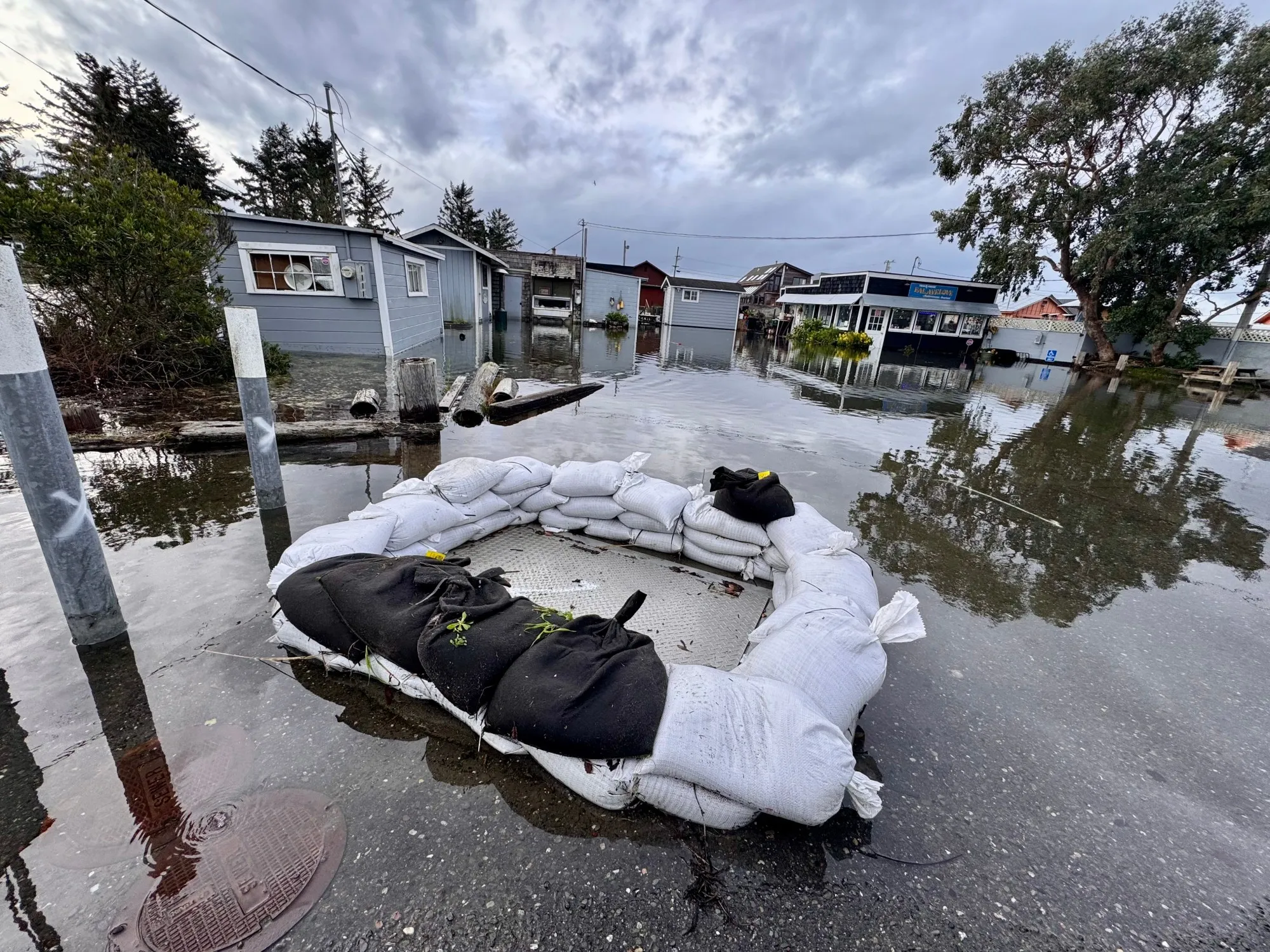
Gian Tuccori and his wife have lived in Fields Landing for less than a year, but this week they found themselves preparing for a situation they never expected: the possibility of having to leave their home ahead of a potentially historic king tide event.
Read more 49ers Faithful swarm Mexico City ahead of Sunday game with Vikings
With a 1-year-old daughter, a second child on the way, and Thanksgiving approaching, the family packed emergency bags and considered where they would go if rising water forced them to leave.
“We definitely packed our bags and were prepared to leave if we needed to,” said Tuccori. “We didn’t want to wait until the last possible minute. If things seem like they are getting worse, our plan is to grab our bags and head to my wife’s parents’ house.”
Tuccori’s family is among residents in King Salmon and Fields Landing now preparing for possible flooding after the Humboldt County Sheriff’s Office of Emergency Services issued an evacuation warning effective Friday. Officials cited a high likelihood of significant flooding associated with king tides and forecast storm activity expected next week.
The warning comes as forecasters closely monitor what could become one of the most significant tidal events Humboldt Bay has experienced in recent years.
According to the National Weather Service in Eureka, some of the year’s highest astronomical tides are expected to peak Nov. 24-26, coinciding with a storm system, elevated ocean levels associated with El Niño, and strong southerly winds. Current forecasts indicate Humboldt Bay water levels could reach approximately 10 feet if the current tidal anomaly persists, while additional storm surge could push water levels near or above the standing record of 10.37 feet, creating the potential for moderate to major flooding around low-lying areas of Humboldt Bay.
“We’re looking at some of the highest astronomical tides of the year coinciding with warmer water off our coastline that’s kind of the impact of El Niño that we’re feeling right now,” said National Weather Service meteorologist Danny Schmiegel. “That warmer water is taking up a little bit more space, so that is one factor causing our tides to already be a little bit higher.”
Schmiegel said a storm system expected to arrive during the peak tidal period could further amplify water levels and increase flood impacts.
“We have southerly winds, which push that water more up against our coastline, as well as some large waves, which push that water even more up against our coastline,” said Schmiegel. “Right now, everything is looking like the potential for a half foot or more higher tides than we usually expect during this time of year.”
The combination of king tides, elevated ocean levels, wave action, and storm-driven winds has forecasters watching closely for potentially record-breaking water levels.
“With those factors adding together, we could even break the previous record high tide that we had last January, particularly for Tuesday and Wednesday,” said Schmiegel. “With those factors adding together, we even see that we could breach the previous record high tide that we had last January, particularly for Tuesday and Wednesday.”
The National Weather Service is also warning that impacts may extend beyond areas that traditionally experience tidal flooding.
“We’re expecting ocean water inundation in areas that we’ve never seen before,” said Schmiegel. “We have some pretty interesting effects with that, with maybe even some levees overtopping.”
Areas being monitored for possible flooding include King Salmon, Fields Landing, the Arcata Bottoms, portions of Highway 101 near College of the Redwoods, state Route 255 near the Mad River Slough bridge, Jacobs Avenue near Murray Field, and Centerville Beach Road. County officials are also monitoring flood-prone locations in the Eel River Valley, Elk River Valley, Freshwater, Jacoby Creek, and Orick.
While the current alert remains an evacuation warning, county officials emphasized that conditions could change rapidly depending on the storm system’s timing and intensity.
An evacuation warning indicates a potential threat to life or property, and residents should be prepared to leave if conditions worsen. Officials have warned that an evacuation order could become necessary as early as Sunday if flooding forecasts worsen.
Humboldt County officials are encouraging residents to start making plans now, particularly those with young children, medical conditions, mobility limitations, or pets who might need additional time to leave safely.
Preparing for the unknown
For Tuccori, the possibility of evacuation has introduced a level of uncertainty his family has never experienced before.
Read more East Bay coastal cities set emergency plans for the next big storm
“When my wife and I first heard about the evacuation warning, it was a bit concerning because we have a one-year-old daughter at home and my wife is currently pregnant,” said Tuccori. “We’ve lived in Fields Landing for just under a year, so we’ve never experienced anything like this before. We weren’t quite sure what to expect when the news came out.”
Tuccori said the family immediately began making preparations in case conditions worsen. While the family remains hopeful they will not need to leave, Tuccori said they are fortunate to have a relatively straightforward evacuation route.
“It should be fairly easy for us to evacuate if we need to,” said Tuccori. “Our property is pretty close to Highway 101, so we should be able to get out fairly quickly. That’s something we’re grateful for given our family’s situation.”
Meanwhile, local agencies are taking steps to reduce potential impacts before water levels begin rising. The Humboldt Community Services District (HCSD) has installed temporary sandbag barriers around storm drain locations in King Salmon. The barriers include one-way check valves designed to prevent Humboldt Bay water from flowing back through the storm drainage system onto neighborhood streets during periods of extreme high tide.
District officials said the effort is part of ongoing work to reduce the impacts of flooding in one of the county’s most vulnerable communities.
The American Red Cross is also urging residents to use the warning to prepare emergency kits, review evacuation plans, and monitor weather forecasts closely in the days ahead.
The organization advises residents not to drive, walk, or swim through floodwaters, noting that six inches of moving water can knock a person off their feet and 12 inches can carry a vehicle away. Residents are encouraged to move valuables to higher ground, secure outdoor items, and ensure they have sufficient food, drinking water, medications, flashlights, and batteries available should roads become impassable or utilities be disrupted.
As forecasts continue to evolve, Schmiegel urged residents in vulnerable areas to pay attention to official updates and evacuation notices.
“Take those evacuation warnings seriously because this is going to be a unique event. We have yet to see tides at this level as of now,” said Schmiegel.
Tide and weather forecasts are expected to become more precise over the next several days as the king tides approach. Until then, emergency officials are urging residents to stay informed, monitor local alerts, and be prepared for changing conditions.
PG&E officials said they are monitoring forecasts as king tides and storm surge threats increase around Humboldt Bay. The utility’s Humboldt Bay Generating Station is located on King Salmon Avenue adjacent to one of the areas under an evacuation warning, though the company said it does not currently expect impacts to its operations.
“PG&E is aware of the forecasted king tides and elevated water levels in the King Salmon and Fields Landing areas,” said PG&E in a statement to the Times Standard. “PG&E does not anticipate any impacts to its facilities or operations. Because localized flooding and road closures may occur in low-lying areas, residents should be prepared for potential power outages and follow guidance from the Humboldt County Office of Emergency Services regarding evacuation warnings, orders, and other public safety information.”
Evacuation zones
The Humboldt County Office of Emergency Services announced Friday afternoon that it has divided the existing evacuation zone covering King Salmon and Fields Landing into two separate zones. According to the agency, the change was made because of the size of the original zone and forecasts indicating that high tides and storm surge could cause significant flooding in both communities.
The King Salmon evacuation area (EUR-E091) will be North of D Street, in Fields Landing, South of Elk River, East of Humboldt Bay, and West of U.S. Highway 101.
The Fields Landing evacuation area (HUM-E091) is North of Humboldt Bay National Wildlife Refuge, South of D Street, East of Fields Landing Boat Ramp, and West of U.S. Highway 101.
Resources and notifications
Office of Emergency Services: https://humboldtgov.org/356/Office-of-Emergency-Services
Read more Sharks’ Warsofsky healthy scratches two lineup regulars for game vs. Kraken
Humboldt Alert: https://humboldtgov.org/alerts
Know Your Evacuation Zone: https://humboldtgov.org/3219/Evacuation-Mapping
Humboldt County road conditions: https://humboldtgov.org/1422/Road-Conditions
Caltrans QuickMap road Information: https://quickmap.dot.ca.gov
Humboldt COAD: https://www.humboldtcoad.org/
Storm supply map: https://findsandbags.org/
Editor’s note: This reporter is related through marriage to Gian Tuccori.
Maranda Vargas can be reached at 707-441-0504
About the Author